I went to Georgia for one reason: I wanted new mountains.
After years of hiking in the Alps —surrounded by overpriced sandwiches and Germans with trekking poles—I needed something different. Enter the Caucasus: wild, dramatic, and still surprisingly underhyped.
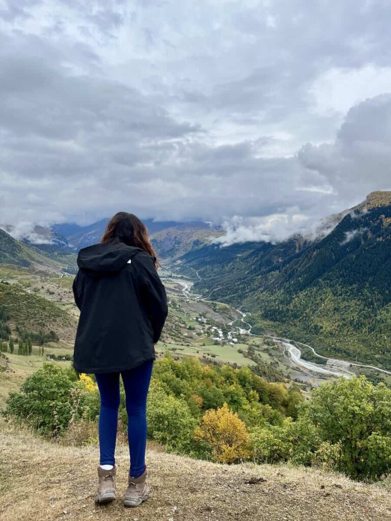
The Mestia to Ushguli trek had been on my list for a while. It’s a four-day hike through Upper Svaneti, Georgia’s most postcard-perfect mountain region, where medieval towers dot the hillsides and cows have right of way. The trail links two mountain towns—Mestia and Ushguli—passing through Svan villages, valleys, and ridgelines that feel stuck in another century.
It was my first multi-day hike in years, and the best part was not having to carry camping gear. You can sleep in guesthouses, eat hot food, and still feel like you’re off the grid. I expected tourist crowds, but even in early October, the trail was quiet. Autumn colors were peaking, the air was crisp, and on some days, we didn’t see more than five other hikers.
Here’s everything you need to know to plan it right.
Quick Facts: Mestia Ushguli Trek
Trail Type | Point-to-point
Distance | ~58 km
Duration | 3–4 days
Difficulty | Moderate (some steep sections, no technical climbs)
Max Elevation | 2,719 m (Chkhunderi Pass)
Min Elevation | ~1,400 m
Best Season | June to mid-October (early October = quiet trails + autumn colors)
Accommodation | Guesthouses in every village — no tent required
Cash | Take enough from Mestia — no ATMs along the trail
Phone Signal | Decent coverage throughout, with the occasional blackout
Navigation | Use maps.me — accurate and reliable
Major Peaks on the Horizon | Ushba (4,710 m), Tetnuldi (4,858 m), Shkhara (5,193 m)
Trek Logistics
When to Go
The best time to do the Mestia to Ushguli trek is June to October.
July and August have the most stable weather but also the most people. I preferred fall —clear skies, thinner crowds, and guesthouses that weren’t fully booked. I hiked in early October and it was perfect: quiet trails, golden trees, and the occasional hiker passing by.
That said, don’t push it past mid-October. Snow can arrive overnight, and some guesthouses start shutting down for the season.
How to Get to Mestia
From Zugdidi
You can catch a daily marshrutka from Zugdidi train station—ride takes about 4 hours and costs 40 GEL. There’s a clear pickup point near the station.
- Morning departure: around 10:00 am
- Afternoon departure: timed with the train arrival from Tbilisi (~14:30)
By Marshrutka
- Zugdidi to Mestia: Daily marshrutkas depart late morning and afternoon. The morning one leaves around 10 am, while the afternoon marshrutka aligns with the train arrival from Tbilisi, departing at 14:30. The journey takes about 4 hours and costs 40 GEL. There is a noticeable bus station just by the train station.
- Tbilisi to Mestia: Direct marshrutkas leave at 7:00 and 8:00 am, taking 9-10 hours. The price is 40 GEL, but the trip is long and uncomfortable.
- Kutaisi to Mestia: A direct minibus departs from the bus station behind McDonald’s between 9:00 and 10:00 am. It costs 40 GEL, and arriving early ensures your spot. If missed, you may need to transfer via Zugdidi.
From Tbilisi
- Direct marshrutka: Leaves daily around 7:00–8:00 am. Takes 9–10 hours. It’s cheap (40 GEL), but long and uncomfortable. If you’re stopping in the capital before heading to the mountains, here’s how to spend a few days in Tbilisi.
- Train + marshrutka combo:
- Train departs 08:20, arrives Zugdidi around 14:20
- Book tickets at railway.ge
- Marshrutkas to Mestia are parked and waiting
- Private taxi: Starts at 550 GEL if booked ahead.
From Kutaisi
- Marshrutka: Leaves between 09:00–10:00 am from the bus station behind McDonald’s. Costs 40 GEL. Get there early to lock in a seat.
- If you miss it, you’ll likely have to transfer in Zugdidi.
- Private taxi: From Kutaisi airport runs about 340 GEL if pre-arranged.
By Plane
Vanilla Sky operates flights from Natakhtari Airport (outside Tbilisi) to Mestia for around 90 GEL. The views are great, but flights are often cancelled last minute due to weather. Book it if it works—but don’t build your whole plan around it.
How to leave Ushguli village?
Leaving Ushguli can be a bit tricky. Your best option is to catch a local taxi for about 40 GEL per person. While some minivans returning to Mestia may have empty seats, don’t rely on them—local drivers prefer to take hikers back themselves. If you want to save a bit, start walking towards Iprali and flag down a minivan once you’re out of Ushguli. From Mestia, catch a marshrutka back to Zugdidi, then continue to Tbilisi as you arrived. The bumpy, river-crossed road makes the 40 GEL fare feel well-earned.
Description of the Route
Day 1: MESTIA – ZHABESHI
Distance | 16.1km
Elevation | ⬆763m and ⬇523m
Time | 5–7 hours (depending on breaks, route, and how often you stop for “just one more view”)
Difficulty | Moderate — one main uphill, gentle descent
Navigation | Maps.me is essential. Don’t wing it.
The trail kicks off from Mestia’s main square. Just head past the new Queen Tamar statue, cross the river, and turn left—basically follow anyone wearing hiking boots and zip-off pants.
You start with a slow climb on a dirt road that takes you past Hotel Tetnuldi and a bunch of wooden chalets. On the right, there’s a hydro construction site—ugly, but useful as a landmark. Eventually, you’ll pass some ruins. Before you get to them, hang a right and start climbing. It’s short but steep enough to get your blood moving.
This section winds through light forest and pastures, and then the views start hitting—Mount Ushba makes a dramatic appearance. Classic Georgia: no warning, just boom, postcard backdrop.
Eventually, you’ll reach a wide-open meadow. Take a break here. It’s peaceful, scenic, and honestly, it feels like you’ve earned it—even if you haven’t. A bit later, you hit the highest point of the day, where Mt. Tetnuldi joins the skyline. This is where you’ll start seeing why people rave about Svaneti.
Trail Split: Classic vs. Upper Route
Not long after the high point, the trail forks. Most people take the wide, obvious dirt track down through Zardlashi and Mushkeli. It’s the easier option—nothing wrong with it, just not that exciting. You’ll be walking along 4×4 roads, passing the occasional cow and crumbling house, until you hit Zhamushi.
I took the upper trail, and if you’ve got decent navigation skills (read: maps.me), I’d recommend it. It breaks off to the left through a forest and opens into sweeping meadows before reaching Lakhiri—a quiet little village that hasn’t yet been swallowed by tourism. It’s peaceful, scenic, and if you’re lucky, you won’t see another hiker for hours. From there, the trail descends steeply into Zhamushi where both routes meet again.
You’ll eventually reconnect with the main trail at Zhamushi, but I’d 100% recommend the upper path if you’ve got some sense of direction and a decent phone battery.
Zhamushi to Zhabeshi
After Zhamushi, the trail curves south toward the Mulkhura River. There used to be a trail along the northern bank, but it got wrecked in a flood, so cross the bridge near Cholashi and continue through Chvabiani to reach Zhabeshi.
I was expecting this part to drag, but it was surprisingly chill—plenty of little guesthouses, roaming cows, and nobody yelling at you to buy fridge magnets.
Where To Stay In Zhabeshi
Guest House Victor in Zhabeshi—10/10 would stay again. The hosts were warm, the food was incredible, and the hot shower felt like a religious experience. It’s not fancy, but it hits that sweet spot between rustic and comfortable.If you want a quieter overnight, you could stop in Lakhiri or Zhamushi instead. Fewer people stay there, and the locals are genuinely happy to host hikers—just expect simpler facilities.
Day 2: ZHABESHI – ADISHI
Distance | 10.6 km
Elevation | ⬆ 909 m and ⬇ 527 m
Time | 4–6 hours
Difficulty | Moderate, but the climb earns its respect
Day 2 starts with a slow, relentless climb—nothing technical, but definitely a “we’re doing this” kind of morning.
Leave Zhabeshi by heading uphill, following the stream out of the village. You’ll cross it just after the last stone tower and house. From there, follow the marked trail southeast. There are a few cow trails that look convincing, but don’t overthink it—just stay on the most obvious path and check maps.me if in doubt.
The trail climbs through a mix of pasture and light forest. It’s peaceful, and the views open up as you gain elevation—behind you, the valley starts to look satisfyingly far away. Two hours in, you’ll hit the Tetnuldi ski resort. You’re already above the base station, so don’t expect much in terms of atmosphere—just some lifeless ski infrastructure and bulldozed tracks. Charming.
From here, keep heading up along the ski lift track. At around 2,500 meters, a sign for “Hadiish” points southeast into the meadows. That’s your exit ramp. The trail curves through fields that were dotted with wildflowers when I passed through in early October—no one else in sight, just wind and color.
Eventually, it dips back into the forest, and before crossing a stream, you’ll spot a “bar”—or more accurately, someone’s shed selling beer and lukewarm Fanta. Still, it’s a nice surprise before the final descent.
Adishi appears out of nowhere—tucked below the slope, completely hidden until the last few minutes. It’s remote, a bit surreal, and easily my favorite village of the trek.
Optional Upper Trail to Adishi
If you’ve got the energy and knees for it, the upper trail is a great detour. It starts higher up, near the exit station of the lowest cable car (the only one that runs in summer). The access point is about 200 meters above the main route—just follow maps.me from Zhabeshi and climb straight up rather than detouring through the ski resort.
The trail cuts across the base of Mt. Tetnuldi with wide-open alpine views the whole way. It eventually turns south and drops sharply into Adishi. You’ll miss the streamside bar, but you’ll also miss the crowds.
Steep descent at the end, though—bring poles if you’ve got creaky knees.
Where To Stay In Adishi
Adishi was my favorite village during the trek. It is the most remote village of all the ones you will visit, a small, charming place with basic facilities, including a bar (though calling it a bar might be generous – —it’s more like someone’s fridge with beers in it. Still, after the climb, it felt like a luxury). I stayed at Guest House Caucasioni — nothing fancy, but it got the job done!

Day 3: ADISHI – IPRALI
Distance | 18.7km
Elevation | ⬆860m and ⬇1069m
Time | 6–8 hours
Difficulty | Challenging—longest day, river crossing, and a decent climb
Guesthouses | Plenty in Iprali. Fewer in Khalde, but more peaceful.
This was hands down my favorite day of the trek—scenic, remote, and just enough drama to keep things interesting.
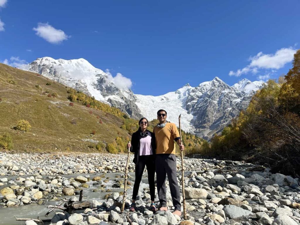
The trail leaves Adishi heading east, following the river. It’s a quiet, steady walk through a narrowing valley toward the foot of the Adishi Glacier. About an hour in, you hit the real challenge of the day: the river crossing.
I’d been stressing about this part. October, cold, snowmelt—I had pre-freeze regret before even dipping a toe. Turns out, it wasn’t that bad. I walked about 50 meters upstream where the river fans out and crossed barefoot with my sandals and hiking poles. Freezing? Yes. Sketchy? No. But that’s early October. If the river’s roaring or you’re unsure, take the horse. Locals usually wait at the crossing during high season and will shuttle you across for around 20 GEL. Bit of a tourist tax, but cheaper than slipping on a rock and baptizing your pack.
Once you’re across, the path climbs through open fields and rhododendron patches toward Chkhunderi Pass (2,655 m). The views here are huge—Adishi Glacier behind you, Tetnuldi and friends ahead. This is where the trek really opens up.
If you’ve got the time and legs for it, leave your bag at the pass and follow the ridge northeast. A quick detour up to a small 2,800 m hill gets you a killer view of Mt. Shkhara, the highest peak in Georgia. It’s only 20–30 minutes round trip, but I stayed up there longer, pretending I wasn’t cold while soaking it all in.
Descent to Iprali (via Khalde)
From the pass, the trail drops quickly into the next valley and then mellows out as it follows the Khaldechala River. About halfway down, you’ll pass Khalde, a quiet little village with just a few families and a handful of guesthouses.
Khalde doesn’t see as many trekkers, and that’s its charm. It was once the heart of an anti-Russian uprising back in the 1800s—burned to the ground in retaliation. These days, it’s a peaceful stop if you want to break up the day, or just avoid the bigger crowd in Iprali.
Where To Stay in Iprali/Khalde
I stayed at the Century House of Larisa, and honestly, it was one of those moments that remind you why we do this. Simple house, zero fuss, and one of the kindest hosts I’ve ever met. We were short on cash and she didn’t blink. Fed us like royalty and sent us off with a full breakfast the next morning. If you do push on to Iprali, it’s another hour or so along the river, mostly flat.
Day 4: IPRALI – USHGULI
Distance | 12.4km
Elevation | ⬆677m and ⬇436m
Time | 4–6 hours
Difficulty | Easy-moderate. One last climb, then cruise into the finish
The last day is the shortest—and honestly, the easiest—of the entire trek. You’ll be tempted to zone out and just follow the road like most people do. Don’t. That road is dusty, trafficked, and a total buzzkill after the quiet trails of the previous days.
Instead, take the forest route. It’s not just prettier—it’s peaceful, shaded, and gives you a chance to enjoy your final stretch without dodging honking jeeps full of day-trippers.
The tricky part is actually finding the trailhead. It starts just after crossing the bridge in Lalkhori. From there, continue towards Davberi, a tiny cluster of houses up on the hillside. The path winds through the village and then starts climbing—nothing too intense, but enough to make you glad you’re not doing this after lunch.
If the path feels confusing at first, don’t panic. Locals are usually around and will point you in the right direction if you look sufficiently lost (or just mildly confused). Once you’re on it, the trail cuts across the slope high above the road and weaves through pine forest, small pastures, and open views toward the Enguri valley. No big landmarks, just a beautiful walk.
Eventually, the trail drops and rejoins the main road for the final couple kilometers into Ushguli. There’s no avoiding it here—but after the serenity of the forest, a bit of chaos feels like a fitting re-entry into the world.
Optional Detour: Latpari Pass Route
If you’re feeling ambitious (and don’t need to catch a ride back the same day), consider taking the Latpari Pass route. It’s a longer, higher detour with proper 360° mountain views over the Svaneti range. The climb is longer and more gradual, and the views at the top are wild if the weather holds.
Worth it? ABSOLUTELY YES—if you’ve got the time, fitness, and patience for a full-day adventure. Just know you’ll need to overnight in Ushguli because you won’t make it in time for the afternoon marshrutkas.
Reaching Ushguli
Ushguli is a cluster of hamlets, so depending on your entry point, you’ll either arrive through Murkmeli or the more central Chazhashi area. Both are photogenic, both have UNESCO street cred, and both offer that dramatic backdrop of Mt. Shkhara, especially in the morning light.
If you’ve got time, stay overnight. The early morning views are what Ushguli is really about—when the clouds lift, Shkhara lights up in full glory, and it’s worth every extra hour you spend here.There’s also a short walk to the Shkhara glacier viewpoint, or a quieter option is to head up to the Chubedishi viewpoint northeast of the village. Fewer people, same jaw-drop effect.

Exploring Mestia and Ushguli
Exploring Mestia and Ushguli
Mestia is where most people start and end their Svaneti adventure, and honestly, it’s not a bad place to base yourself. The town’s grown a lot in the last few years—there are ATMs, decent coffee shops, guesthouses on every corner, and just enough tourist infrastructure without feeling like a theme park.
The watchtowers are the main thing here—tall stone structures that once protected villagers from invaders (and each other). You’ll see them everywhere. Some are attached to museums, others to homestays. The best one I visited was open for a few lari and came with rickety wooden ladders and zero safety measures—peak Caucasus.
Ushguli, on the other hand, feels like stepping into a medieval film set—minus the film crew. It’s one of the highest permanently inhabited villages in Europe, and somehow even more dramatic than Mestia. Four hamlets sprawl across the valley, all with watchtowers, stone houses, and a backdrop of Mount Shkhara looming in the distance like it’s showing off.It’s quiet, beautiful, and full of character. Some parts are crumbling. Others are full of kids riding horses and locals selling honey from their front steps. If you’ve made it this far, spend the night—the best views are at sunrise, when the light hits the peaks and the tourist jeeps haven’t arrived yet.
Mestia to Ushguli Trek: Cost Breakdown
Here’s the total cost breakdown of the trek.
| Item | Cost (GEL) | Notes |
|---|---|---|
| Marshrutka: Zugdidi → Mestia | 30 | Or shared taxi if you’re fancy |
| Marshrutka: Ushguli → Mestia | 30–40 | Shared taxi likely |
| Accommodation (per night) | 20–30 | Includes dinner + breakfast |
| Meals on the trail | 25–30 | Hearty, usually homemade |
| Horse to cross Adishi River | 20 | Optional but useful |
| Beer / Wine (optional…ish) | 10 | Warm welcomes, cold drinks |
⛺️ I’ve put together my full backpacking gear list here if you want to see everything I carry. You can also browse it all in my Amazon storefront.
Final Thoughts
The Mestia to Ushguli trek isn’t just one of the most beautiful hikes in Georgia—it’s also one of the most accessible multi-day hikes in the Caucasus. No tent, no heavy gear, no permits. Just stunning views, warm meals, and a daily dose of Svan hospitality.
If you’re craving big mountains, quiet trails, and a bit of a cultural reset, this is your sign to book the trip.
And when you do—take the upper trails, skip the main road, and say yes to the homemade chacha (at your own risk).
If you’re planning to spend longer in the country, here’s what it’s like to work remotely in Georgia as a nomad.
If you’re traveling on a Pakistani passport and always on the hunt for places you don’t need to beg a consulate for, here’s a growing list of visa-free destinations that actually deliver.
FAQs
Is the trek safe? Can you do it solo?
The trek is generally safe, with well-trodden paths and cell coverage for most of the route. Solo travelers, including women, can do it safely, but it’s important to use common sense and put in some extra effort to stay safe —stay at official guesthouses, avoid private invitations, and consider sticking with other hikers. The trail sees plenty of trekkers, so help is usually nearby if needed.
How busy is this trek?
The trek’s popularity has fluctuated, with pre-COVID numbers reaching 100-150 trekkers daily in peak season. While 2023 saw a rebound, it’s still less crowded than before. If you want a less crowded experience with genuinely welcoming guesthouse hosts, 2024 is a great time to go.
Do I need a guide for the trek?
You do not need a guide for the Mestia to Ushguli trek, but it’s essential to download the maps.me app before starting. The trail is well-marked, and most trekkers navigate it independently. Just make sure you have your phone, charger, and the Georgia map downloaded on the app to guide you.
Should I book accommodation in advance?
You should book accommodation in advance if you’re trekking in July or August, as the best places fill up quickly. While locals might help you find a spot if needed, it might not be the most comfortable option. To play it safe, booking online or asking your landlord in Mestia to book for you is recommended, especially for peak season.
Where can I leave my luggage in Mestia?
There is no official luggage storage in Mestia, but you can leave your excess luggage at the guesthouse where you stay. It’s a common practice, especially if you plan to stay there again on your return. Just ask your host, and they’ll likely store it for you, making your trek lighter and more comfortable.
Can I start trekking on the same day as arriving in Mestia?
No, it’s not recommended to start trekking on the same day as arriving in Mestia. Since the night train from Tbilisi to Zugdidi was canceled, the earliest marshrutka arrives in Mestia too late in the day. It’s better to take your time, explore Mestia, rest after the long drive, and enjoy a nice dinner before starting your trek the next day.
Which way should I hike?
Most people start the trek from Mestia to Ushguli, and for good reason. Starting in Mestia means you’ll reach the tricky river crossing beyond Adishi in the morning when river levels are lower. However, starting in Ushguli is becoming more popular for those seeking solitude on the trail. Ultimately, both directions are doable, but Mestia to Ushguli is the more traditional and convenient route.
Is it possible to trek Mestia to Ushguli in 3 days?
Yes, it’s possible to complete the Mestia to Ushguli trek in 3 days, focusing on the best parts of the trail. While most people take 4 days, you can shorten the trek by taking a taxi from Lalkhori to Ushguli at the end of day 3. This allows you to spend an extra day exploring Ushguli, the highest inhabited settlement in Europe.
What should I pack for the Mestia to Ushguli hike?
Pack as light as possible—every extra kilo will feel heavier by the end of the day. A 30L daypack should suffice. Bring essentials like a rain jacket, fleece, hiking boots, water bottles and a sun hat. Don’t forget your phone with the maps.me app, cash (no credit cards accepted), and a basic first aid kit. The guesthouses provide towels and bedding, so no need to pack those.